On 28 August 2026 the sea pulled back from several beaches in Cartagena, Spain. At the harbour tide gauge we measured a 14.8 centimetre drop in eight minutes. Four days earlier, at the port of Gandia, the same kind of event gave 62.1 centimetres under the same filter.
And the air, by its own weight, only explains three.
That subtraction is the question in this piece. One hectopascal, the unit atmospheric pressure is measured in, moves sea level by one centimetre. This is the inverse barometer effect, and oceanographer Francisco López Castejón, of the Technical University of Cartagena, explained it those days without any formulas, as reported by Mazarrón Noticias: “If we squeeze the water in a bucket, it rises on the other side. The sea does the same: if air pressure suddenly rises, the water shifts and the level drops”.
And the pressure did move that morning. Murcia-San Javier airport sits three metres above the sea, right at the northern end of La Manga, and its routine reports give 1017 hectopascals at 09:00 UTC, 1020 at 09:30 and 1017 again at 10:00. Three up and three down, in the same half hour the tide gauge dropped its fifteen centimetres. By air weight, three hectopascals are three centimetres. That leaves twelve missing. And at Gandía, where the sea dropped sixty-two, far more is missing: we have not measured the pressure there, so all we know about that gap is that it is large.
Resonance, in one sentence
The usual explanation is resonance. A pressure disturbance travelling over the sea pushes a long wave along: a wave kilometres wide and a few centimetres high. If it advances at the same speed as that wave, the push always arrives in phase and the wave grows kilometre by kilometre. It is like pushing a swing at exactly the right moment, over and over.
It is called Proudman resonance, it was described in 1929, and the canonical review by Monserrat, Vilibić and Rabinovich in Natural Hazards and Earth System Sciences puts it like this: it happens “when U=c”, that is, when the speed of the disturbance equals that of the long wave.
And here is the part that turns this into a map problem: the speed of a long wave depends only on depth. The deeper the water, the faster it travels. So for each speed of the disturbance there is one specific depth at which the two match. The same authors place resonance in “extensive shallow-water regions” of between 40 and 160 metres.
The speed we have is borrowed
For this coast there is a speed reviewed by the Spanish met office, but it belongs to a different event. In Sinobas, where AEMET collects rare phenomena, the reviewer who validated the record of that Santa Pola event noted that the disturbance “was moving at an average speed of 90 km/h”, and that this “favours the so-called Proudman resonance”.
That same record states that no AEMET report exists on it and that it cannot be used for administrative or legal purposes. And for 28 August 2026 we have no measured speed at all.
So what follows is a calculation with a borrowed number, and that is worth keeping in view throughout. If the disturbance moves at 90 kilometres per hour, the long wave runs at that same speed wherever the seabed lies 64 metres down.
Where that seabed is
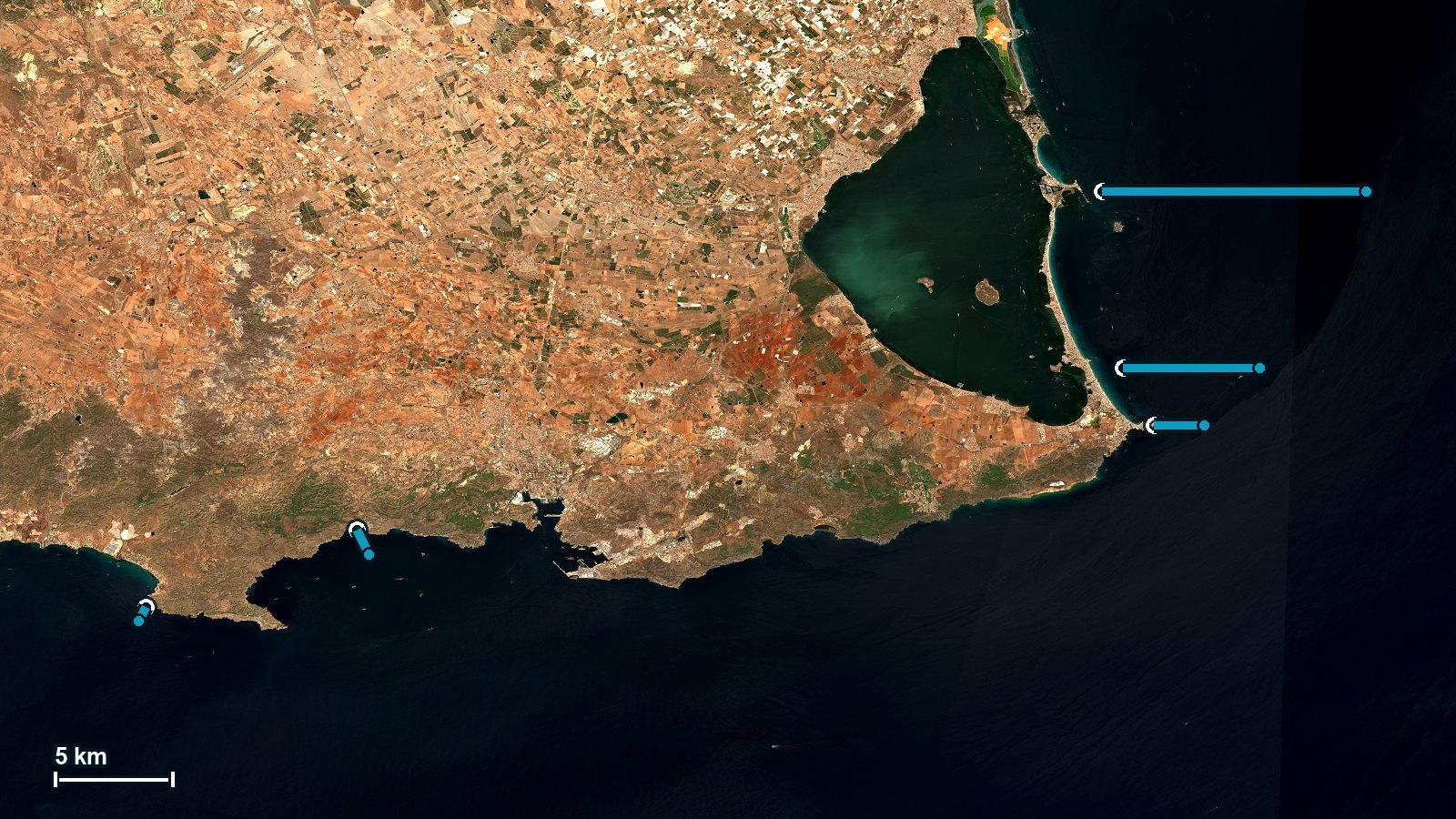
With that depth in hand, the question becomes concrete: how far from each beach does the seabed reach 64 metres? The answer comes from the bathymetry of EMODnet Bathymetry, the European reference.
The seabed reaches 64 metres eight hundred metres off La Azohía. Eleven kilometres off the northern stretch of La Manga. At Cabo de Palos, two.
That is fourteen times farther out, across thirty kilometres of coast. The same air wave finds the depth it needs at wildly different distances depending on the stretch, and that spread is the first suspect for why on the same day some places notice the oscillation and others barely do.
It also explains why the tide gauge inside the port of Cartagena, sheltered by its breakwaters and twenty-five kilometres from those beaches, need not record what was seen there. The fifteen centimetres are what happened in that harbour. They are not what happened at La Manga, and no instrument says what did.
This is not a demonstration, for two reasons
The first is size. The review we cite requires large expanses of shallow seabed, and we measured a single profile perpendicular to the coast. A profile is not an expanse.
The second is direction. The AEMET record itself stresses that the port of Santa Pola was “open to the south, perpendicular to the direction of travel of the wave”. Our calculation does not look at direction at all: it gives the same answer whichever way the wave came from.
It is good for knowing where to look. It is not good for setting a bound, nor for claiming that Proudman resonance occurred off La Manga on 28 August.
What it would take to settle this
It would take pressure minute by minute. What exists is airport reports every half hour in whole hectopascals: enough to see that there was a three hectopascal swing, not enough to time it. And one barometer would not be enough either: speed is measured by watching the same jump arrive at different times at two or three points along this coast. That would settle whether resonance happened at all.
And it would take a sea level station recording every minute on open coast, outside the shelter of a harbour, between Cabo de Palos and La Manga. Today the whole coast of the Region of Murcia is covered from a single point, inside a port. For tides and mean level that is enough. For an oscillation of minutes that amplifies with the shape of every inlet, physics says it is not.
The phenomenon has come back three times in five years: 2021 at Santa Pola, 2026 in Valencia and in Murcia. Measuring it properly is what we do in marine and coastal monitoring, and here, as with the low water on the Rhine, what is missing is not data: it is the place to take it.