On June 26, 2026, ESA published a comparison of southern Egypt in its Earth from Space series, close to the border with Sudan: two Copernicus Sentinel-2 scenes taken ten years apart. In the 2015 image, sand dominates. In the 2025 image, the desert is dotted with perfect circles.
And those circles are red.
It is not an artistic filter and it is not a mistake. It is the most interesting technical decision in the whole image, and it explains something anyone working with satellite data needs to understand: the color of a scene is not what is there. It is what you chose to look at.
What ESA chose to look at
The official image page says it plainly: “These false-colour images have been processed using Sentinel-2’s near-infrared channel to display vegetation in red”. These are not photos. They are false-color composites that use the near-infrared channel to paint vegetation red.
Why bother? ESA gives the reason: “The resulting range of colours, from red to brown, is a more accurate representation of different types of crop or different growth stages, compared to true-colour images”. In plain terms: red separates crop types and growth stages better than natural color does.
That is the key. Healthy vegetation reflects a lot of near-infrared, far more than any other surface. That channel, invisible to the human eye, separates living from dead with a clarity green never reaches. Painting it red is not makeup. It brings information that was always there into the visible range. It is the same logic behind choosing the band combination that turns the ice blue at Great Bear Lake.
Our version, in true color
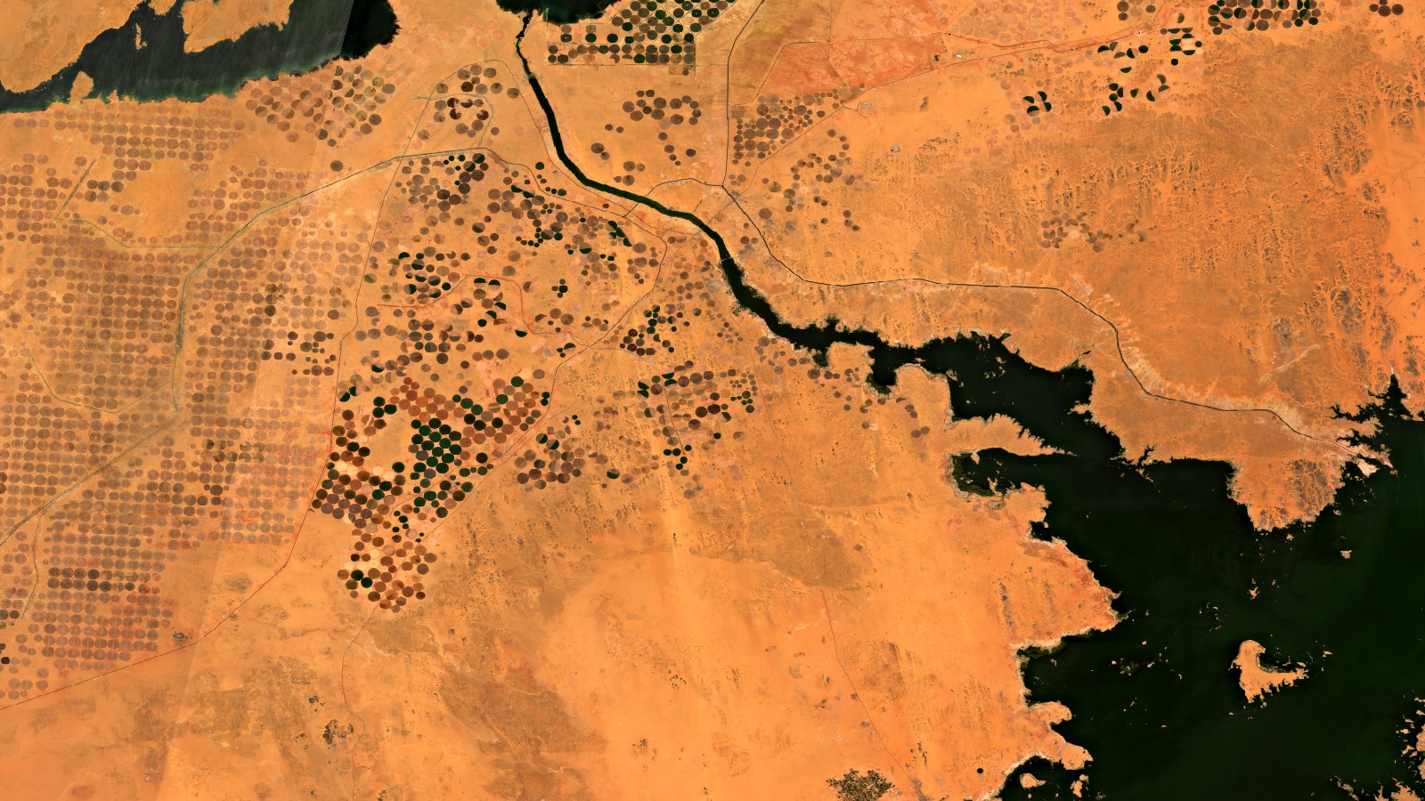
The image at the top of this article is ours. We recreated it from the Copernicus Data Space Ecosystem with processed by T3 AISAT, using Sentinel-2 L2A data from June and July 2025, in true color: what your eye would see from the 786 kilometers where Sentinel-2 orbits.
And so you do not have to imagine anything, here is that same scene, also recreated by us, in false color with the near-infrared painted red, the same technique ESA uses:

Compare the two and you can see what each decision costs.
In true color, the circles show up in brown and ochre tones, and only a few are clearly green. It is pretty and it is honest, but telling a ripe crop from stubble is hard. In false color, those same circles separate into a range of reds that tells you at a glance which one is in full vigor and which one has been harvested.
Neither one lies. They answer different questions. And picking the wrong question is the most common mistake people make when they start with remote sensing.
What both images do show
Under the color decision, the facts do not change, and they are remarkable.
ESA sums up the transformation this way: “over time, land cultivation has increased, transforming the area into viable agricultural land by 2025”. In one decade, bare desert became productive farmland.
The circles have a mechanical explanation. As ESA describes it, most of the cropland is divided into circles up to 800 meters wide, from center-pivot irrigation: an arm of sprinklers rotating around a well at the center of each field. Since nothing grows in that climate without intensive irrigation, the fields are round by necessity. The geometry of the field gives away the irrigation method.
The water comes from Lake Nasser, the great reservoir on the Nile, visible in black in our scene. Canals appear as thin dark lines cutting through the fields. Above them sit the Toshka Lakes, a thermometer for the Nile itself: ESA documents that they shrank significantly between 2012 and 2018, and that summer rains in Sudan in 2019 and record floods in 2020 refilled them, appearing full in 2025.
What you take away
That color is a parameter, not a fact. That the same scene, processed two ways, answers two different questions, and neither one is the true one.
That is exactly the work we do in the environment and water sector: not downloading images, but deciding which band, which index, and which processing turn a pixel into an answer. If you manage irrigation, a vegetation index tells you which sector is suffering before you can see it with your eyes. If you work for a public agency, comparing dates gives you actual irrigated area against declared area. If you are responsible for a reservoir, the archive measures its water surface back to 2015.
All of it comes from the same open data ESA used to paint these circles red, and that we used to paint them ochre. It is available to you today, for free. The hard part was never getting the image. It is knowing what to ask it.
If you want to know what you can ask Sentinel data about your fields, your basin, or your territory, get in touch.
Source: ESA, Earth from Space: Desert cropland, 26-06-2026. Attribution of the original scene: “contains modified Copernicus Sentinel data (2015/2025), processed by ESA”. We do not reproduce it here: you can see it at the source.