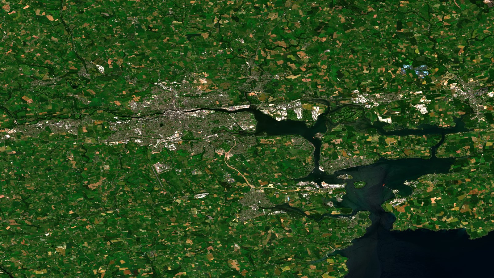
On July 1, 2026, the European Union space program picked a special scene as its image of the day: the city of Cork, Ireland, seen by one of the Copernicus Sentinel-2 satellites. At first glance it is a portrait of a city and its harbor. Look closer and it becomes something else: a clear snapshot of how European farmland works, and of everything Earth observation can do for it.
One image, two stories
The scene was acquired by Sentinel-2 on 23-06-2026. According to the official description from the EU Space Support Office, the image shows Cork, Ireland’s second largest city, where the River Lee widens into Lough Mahon, the inlet that forms the northwestern part of Cork Harbour. The original caption puts it this way: “The urban area appears in pale grey and pink tones, contrasting with the surrounding patchwork of bright green and straw-coloured agricultural fields.”
The publication date was not random. On that same July 1, Ireland took over the rotating presidency of the Council of the European Union. The official presidency website states it plainly: “The Irish government holds the Presidency from 1 July to 31 December 2026.” The image of the day works as an institutional greeting. It is also a reminder that the Copernicus program watches every corner of Europe with the same data quality.
The patchwork that matters to us
For those of us who work with satellite data applied to agriculture, the most valuable part of this image is not the city. It is everything around it. The official description mentions a landscape dominated by “a dense mosaic of fields separated by hedgerows and small roads.”
That mosaic tells a farming story in two colors. The bright green fields are crops and pastures in full growth. The straw colored fields are freshly cut parcels or crops ripening toward harvest. In a single satellite pass, without setting foot on the ground, you can tell which parcels are in which stage. Add a frequent revisit cycle and you get a complete movie of the growing season, parcel by parcel.
This is exactly the logic we apply at T3 AISAT when we combine Earth observation, artificial intelligence, and GNSS positioning. The satellite provides a continuous view of the land. AI turns pixels into useful information: crop condition, changes in land cover, parcel boundaries. GNSS anchors every data point to a verifiable position on the ground. The result is agricultural and environmental information with technical backing, ready to support decisions and to serve as evidence.
The technology behind the scene
Sentinel-2 is one of the reference optical missions in the Copernicus program. According to the official factsheet of the Copernicus Data Space Ecosystem, the mission carries an optical instrument that samples 13 spectral bands: four bands at 10 meter resolution, six at 20 meters, and three at 60 meters, with a swath width of 290 kilometers. The full mission specification provides a revisit frequency of 5 days at the equator, and European latitudes can see even shorter gaps thanks to orbit overlap.
The same source sums up the mission’s purpose: it “aims to monitor changes in land surface conditions,” with applications that range from agriculture and land monitoring to emergency management and climate analysis.
For the agri-food sector this means something very practical. At 10 meter resolution, each pixel covers an area smaller than a tennis court. That is enough detail to work at parcel scale across most of the territory, and the short revisit cycle makes it possible to catch an irrigation issue, a mowing event, a change in land use, or a crop problem while there is still time to act.
Recreate it yourself
One of the best things about Copernicus is that its data is open. The Cork scene is available to anyone through the Copernicus Data Space Ecosystem and its Copernicus Browser. Search the Cork area (around 51.9 north, 8.4 west), filter for Sentinel-2 Level 2A on 23-06-2026, and compose the image in natural color using bands B04, B03, and B02. From there you can also explore false color composites that highlight vegetation, the same technique we used to paint the pivot fields of the Egyptian desert red using the near infrared band B08.
What we take away
An image meant to celebrate a European presidency ends up teaching something more lasting: Europe’s land, urban and rural, is being observed continuously, openly, and with enough technical quality to work at parcel scale. It does not matter whether the patchwork sits in County Cork or in the fields of southeastern Spain. The infrastructure is the same, the data is public, and the potential for agriculture, the environment, and land management is there, waiting for someone to turn it into decisions.
At T3 AISAT that conversion is our daily work: from pixel to data, from data to evidence, and from evidence to value for the agrifood sector. If you want to see how this applies to your farm or your organization, let’s talk.
Sources: EU Space, Copernicus Image of the Day: Cork, 01-07-2026, and the official Sentinel-2 mission factsheet from the Copernicus Data Space Ecosystem. Original image attribution: European Union, Copernicus Sentinel-2 imagery. We do not reproduce it here: you can see it at the source.